The
Sonora Desert region has survived, in part, because of the dedicated efforts of
individuals, communities, and state and federal agencies that recognized the
importance of protecting this unique biosphere.
Within
the city of Tucson is Tohono Chul Park, a forty-nine acre desert preserve. It is
noted for its native-plant collections and ethno-botanical gardens. The passage from Isaiah 35:1, “The desert shall flourish and blossom as
the rose” is certainly true in this beautiful urban park.
 |
Courtyard in Tohono Chul Park. For our St. Louis friends, this park has
a reciprocal admission agreement with the Missouri Botanical Garden |
 |
| The garden is awash in color. This photo was taken in March |
 |
| Palo Verde (Spanish for "green pole" or "green stick") trees |
 |
| Gopher plant |
 |
| Azurite and Malachite stone, donated to the park in 2002, weighs 4,650 pounds |
 |
Agave Americana or Yucca plant. Early people used the
spines of this plant to make needles and thread for sewing |
 |
| "Teddy Bear" cactus |
 |
| Hawk visiting the garden, searching for rodents for lunch |
 |
| Fountain wall. Tohono Chul features many cool, relaxing areas within the garden |
Also
in Tucson, out near the western end of Broadway, is Sentinel Peak Park, better known as “A”
Mountain. Each year the big letter “A” built into the face of the mountain is white-washed
by University of Arizona freshmen. There is a gorgeous view of the city from the
park.
 |
For a perspective of just how big the "A" is, note the line of
cars creeping up the road just at the base of the big letter |
 |
View of Tucson from the top of Sentinel Peak ("A" Mountain).
The Santa Catalina Mountains can be seen in the distance |
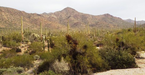
Eight
miles west of the downtown area is Tucson Mountain Park, encompassing 20,000 acres of the Tucson Mountains and adjoining mesa land. It embraces one of the largest areas of
saguaro (pronounced sue-war'-o) cacti and natural growth in the Southwest. Gates Pass, the quickest
route over the mountains to the park, offers scenic vistas. Camping is available in the park at the Gilbert
Ray Campground.
 |
| The Tucson Mountains as seen from the campground in Tucson Mountain Park |
 |
The Saguaro Cactus can grow to 40-50 feet tall. It does
not begin to sprout "arms" until it is about 75 years old |
Saguaro
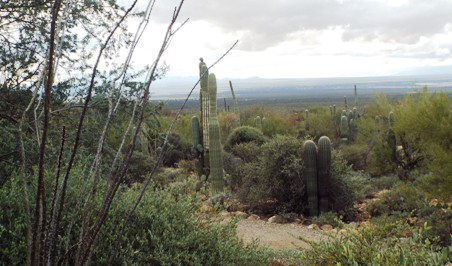
National Park is separated by the city of Tucson into two distinct districts.
Fifteen miles west is Saguaro West - Tucson Mountain District. The scenic Bajada Loop Drive is an unpaved
route which allows the visitor to be immersed in nature. A short walk from the Signal Hill picnic area
is a fascinating spot where ancient petrolglyphs can be viewed. East of the city lies Saguaro East - Rincon
Mountain District. Cactus Forest Drive
is an eight mile paved route with pull-offs to allow longer stops for viewing.
Together the two districts encompass 91,300 acres.
 |
Although best known for the Saguaro Cactus, the Sonora Desert
is home to many different species of cacti |
 |
Although the Saguaro Cacti can live to upwards of 200 years and
towers 50 feet tall, in its first 8 years, it only grows 1 to 1.5 inches. |
 |
| Pin Cushion Cactus just starting to bloom in March |
 |
| Saguaro National Park - West, approaching the area of the petroglyphs |
 |
This walkway was built by the Civilian Conservation Corps in the 1930's.
It goes from the Signal Hill picnic area to the site of the petroglyphs |
 |
| This ancient picture on the rock could depict the sun or the entire universe |
 |
| More ancient carvings on the rocks at Signal Hill |
 |
A crested or "cristate" saguaro. Some speculate that the crest is a genetic
mutation; others think it may be the result of a lightening strike or a freeze..
National Park Service scientists say they simply do not know the cause. |
 |
The crested saguaro is relatively rare. Only 1 in about 10,000 cacti
develop the crest. We saw three, but there are more than twenty-five
located within the boundaries of Saguaro National Park |
Seventeen
miles east of town in the foothills of the Santa Catalina Mountains, within the
Coronado National Forest, is Sabino Canyon.
As early as 1,200 AD Hohokam Indians built irrigation dams in this area.
It is estimated that 1.25 million people
visit this park annually. There are numerous hiking trails but no vehicles are
allowed beyond the park gate. In the
1930s Civilian Conservation Corps workers built bridges and 3.8 miles of
road. Today visitors can catch a tram
and enjoy a forty-five minute narrated excursion through the canyon.
 |
| Looking down Sabino Canyon from near the top |
 |
The trams cross several "low-water bridges" in their treks up and
down the canyon. In rainy season, those bridges can't be crossed |
 |
| The top of Sabino Canyon |
 |
Yvonne's parents, Tracy and Dorothy Brown, spent two
weeks with us while we were in Tucson |
In
the midst of the Great Depression, former U.S. Postmaster General Frank
Hitchcock called in some federal favors and received money and convict labor to
begin building a road into the Santa Catalina Mountains. The CCC eventually finished the job. During the 1940s a real estate agent sold plots
for the town of Summerhaven. Ski Valley,
located within Summerhaven, is the nation’s southern-most ski slope.
 |
| "Sky Island Highway" as it twists and turns its way down the mountain |
 |
HooDoos. The term actually came from white pioneers who, when they
saw these rocks emerging from the mist and fog on the mountain,
thought they looked like magical beings. |
Another
dramatic geographic feature can be experienced in the mountains about 120 miles
southeast of Tucson. The Apache called
this geographic phenomenon “Land of Standing Up Rocks”. It is known today as Chiricahua (pronounced
chair-a-kow’-a) National Monument. Craggy rhyolite pillars dominate the
landscape. This is a land of myth and
legend.
 |
Chiricahua National Monument and the surrounding mountains was the
home of the legendary Apache leader and medicine man, Geronimo |
 |
Due to its high silica content, rhyolite lava is very viscous. It flows slowly, like
toothpaste squeezed out of a tube, and tends to pile up and form lava domes |
 |
Chiricahua National Monument encompasses some 11,985 acres
and is administered by the National Park Service |
 |
Geronimo lived to the age of 80, the last 23 of which were spent as a.
prisoner of war. 5,000 U.S. Soldiers - nearly a quarter of the Army -
took part in the final hunt for, and capture of, the famed warrior. |
 |
| "Other-worldly" might be an appropriate way to describe this land |
The
Sonoran Desert is far more than just an arid, harsh piece of land. It is a region full of intense natural beauty that holds
secrets and stories from ancient times.
But it must be respected and protected so that future generations of visitors
can discover their own Road Stories.


